The Battle of the Egadi Islands (10th March 241 BC) is the only known ancient naval battlefield. Fought 3 nautical miles west of Sicily, the battle was the final naval engagement of the First Punic War. Today, the site is internationally significant as the earliest assemblage of Roman Republican and Carthaginian warship remains and military equipment. A marine protected area (MPA) encompasses the site, but since it lies offshore, traditional ship-based monitoring provides limited protection to threats such as fishing damage and looting. Advances in remote sensing and satellite imagery analysis offer a solution. Partnering with MAST and OceanMind, through the Maritime Observatory partnership, the global leader in marine monitoring, this project will apply cutting-edge methods and technology to help protect the Egadi MPA and develop a capacity-building white paper for the Honor Frost Foundation (HFF) website that will aid researchers and heritage managers in the HFF region.
![]() OceanMind is a not-for-profit organization based in the UK with a mission to deliver actionable insights into human activity at sea. We work confidentially in partnership with governments, NGOs and businesses, providing leading maritime intelligence, capacity building, and strategic support to enhance governance and sustainability in the marine environment.
OceanMind is a not-for-profit organization based in the UK with a mission to deliver actionable insights into human activity at sea. We work confidentially in partnership with governments, NGOs and businesses, providing leading maritime intelligence, capacity building, and strategic support to enhance governance and sustainability in the marine environment.
MAST (Maritime Archaeology Sea Trust) has become a champion for maritime heritage in the UK; conducting maritime archaeological projects; influencing heritage management by Government; increasing public awareness, education, training and campaigning.
![]() MAST leads the ongoing investigation into the exploitation of UK historic wrecks by commercial salvors including the destruction of designated World War One wrecks in the North Sea and World War Two wrecks in the Java Sea.
MAST leads the ongoing investigation into the exploitation of UK historic wrecks by commercial salvors including the destruction of designated World War One wrecks in the North Sea and World War Two wrecks in the Java Sea.
The Maritime Observatory is an innovative collaboration between the Maritime Archaeology Sea Trust (MAST) and OceanMind to protect the most vulnerable submerged cultural heritage sites world-wide. Harnessing cutting-edge satellite and machine learning technologies developed for monitoring commercial fishing, the Maritime Observatory’s mission is to detect, deter, and disrupt heritage crime at sea. The Maritime Observatory is the foremost provider of these services to UK and European Government Departments, Non-Governmental Organisations and charities.
The team will be working with the University of Cranfield to produce the white paper in 2023-24 which will be available for wider application and academic research.
2024 Report
The team analysed data from 3 satellite sources – Automatic Identification System (AIS), Visible Infrared Imaging Radiometer Suite (VIIRS), and Electro-optical (EO) to identify activity that could pose a threat to the site. Our findings suggest that there is a significant risk from fishing and ‘dark’ vessels operating over the site. The project demonstrates how the use of remote sensing offers new opportunities for the monitoring of maritime archaeological sites and will aid researchers and heritage managers in the HFF region.
Key findings
- The ancient battlefield lies under a busy modern shipping lane and a wide range of maritime activities are carried out over the site.
- The greatest threat appears to be from fishing damage. 7 trawlers were detected operating over the site. 1 vessel was responsible for 33 of the 42 identified fishing incidents. Suspicious behaviour including AIS gaps and avoiding fishing when official vessels were present may indicate these were deliberate incursions. This information was passed to law enforcement for further action.
- Electro-optical analysis indicates that not all vessels operating over the site transmit on AIS. ‘Dark’ vessels were observed frequently with detections peaking in July and August. Future monitoring will target these summer months.
- The implementation of an ongoing monitoring programme is recommended for underwater sites in the region. With the cost-effectiveness of satellite surveillance for intelligence gathering, traditional methods of marine protection (i.e. patrols and inspections) can then be targeted more efficiently.
Phase 1
To analyse one year of data for the battle site within the Egadi MPA and generate a report of vessel behaviour which can be used to facilitate traffic management in the protected area and prevent illegal activity on site.
Aims:
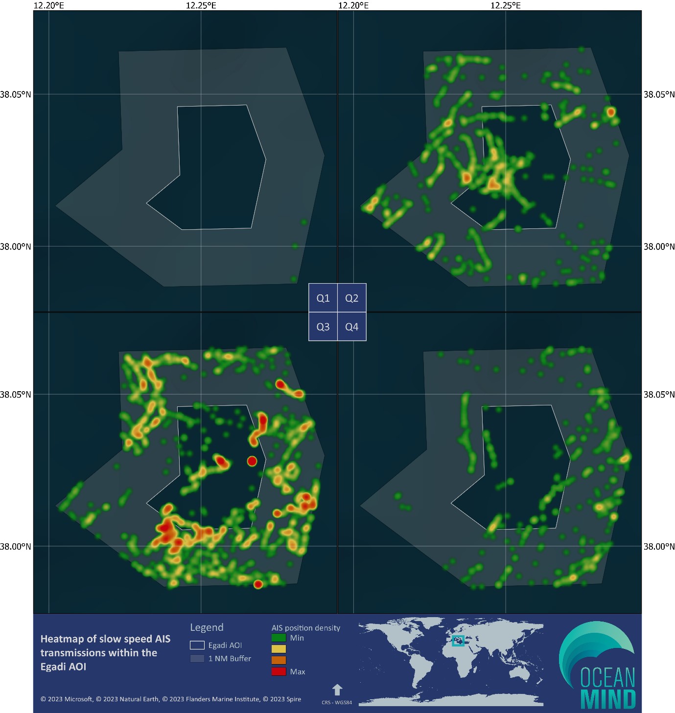
- AIS analysis of all vessels near the site for risk of damaging interactions with the seabed such as fishing, dredging or cable laying. Also analysis of gaps in AIS transmissions by vessels that start or end within the project area that may pose a risk to the site.
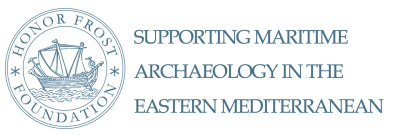
- Spatial and temporal activity from AIS, including heat maps and summary statistics of the different types of vessel activity in the project area, and qualitative identification of any trends in vessel activity over the analysis period.
- Use of VIIRS light sensor data to detect ‘dark’ vessels in the project area and quantify the risk posed.
- Identify and review vessels of interest.
- Review the status of the site and any changes that might indicate dates of interaction.
All phase one project aims were successfully completed between Dec 2022 and April 2023. The confidential full report was submitted to the Soprintendenza del Mare, Regione Siciliana and Carabinieri of Trapani. The redacted report (with specific vessel identities removed) was submitted to HFF for comment.
Phase 2- In progress
Create a capacity-building white paper on the data sources and methodologies available for remote monitoring of maritime spaces, developing the discipline of maritime archaeology through knowledge exchange of this data and methods. The White Paper is currently being written.