
Introduction
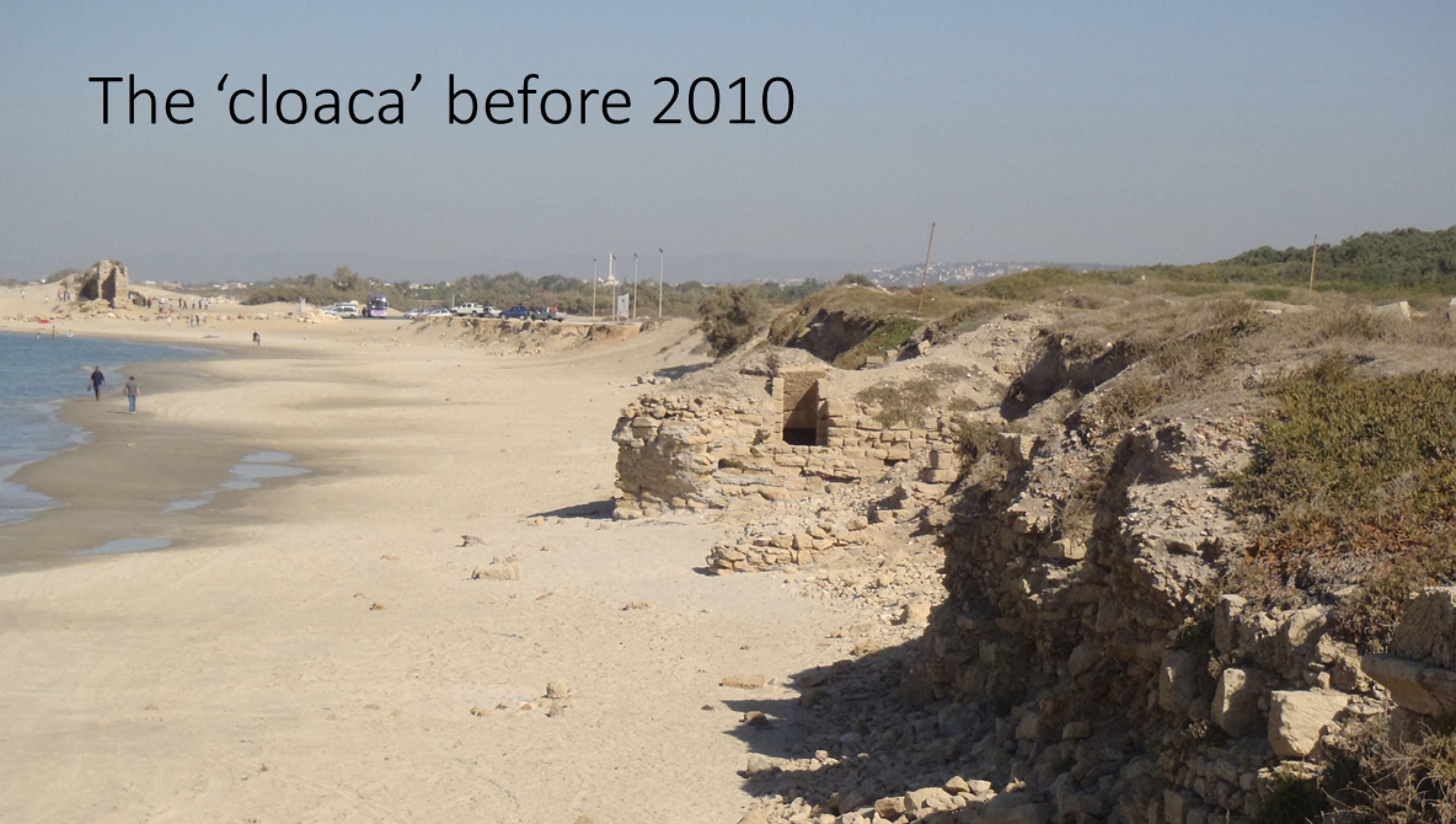
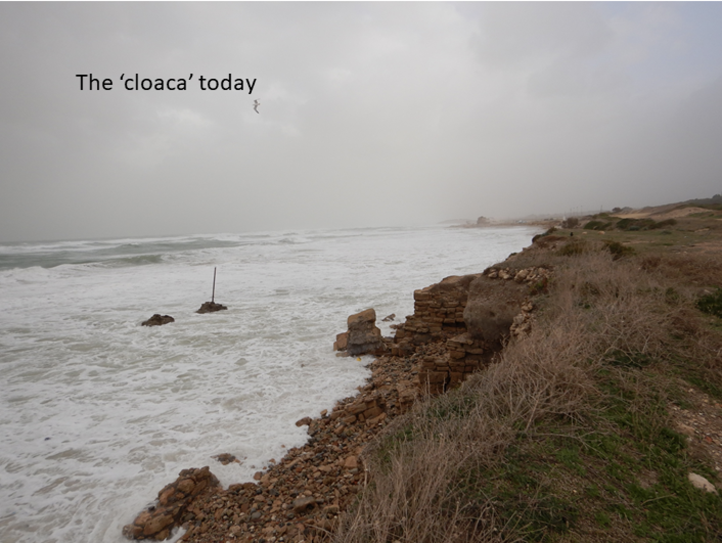
The little researched Roman and Byzantine Period ‘Cloaca Maxima’ (canal), located on the coastline north of Herod’s port in Caesarea, has suffered constant destruction and deterioration in recent years, as a result of winter storms, coastal erosion, and human activity. Many coastlines worldwide are being impacted by coastal erosion. The original coastal configuration of Caesarea is not agreed upon, and there are multiple theories regarding the coastal morphology at the time that Herod constructed the Roman-era harbor and associated monumental features. Searching underwater for the continuation of the canal can be used as a relative marker for distance from the ancient waterline, both vertically and horizontally. The true purpose/s and technical functioning of the canal is also not entirely clear. Though it is presumed that it was a major (maxima) exhaust for sewage and liquid waste, it has also been suggested that it served a flushing function for the entire infrastructure of the city plumbing system based on descriptions from Josephus and possibly a direct relationship to the ancient harbor for the purposes of keeping the harbor clear and operational. In 2010, an unexpected layer of fine silty mud was identified nearly 600 meters offshore of the cloaca and is suspected to be a rare patch of preserved sewage effluent. In this study, by analyzing the canal’s association to the aqueducts (low and high), the Roman and Byzantine city and these offshore sediments will help to complete the missing information about the water system in Caesarea. Since the canal has never been fully published and is under a process of rapid and continuous collapse, this research is of utmost importance. The main target of this research is to answer the question Where was the original position of the seaward opening of the Cloaca Maxima, and how does it relate to current and past coastlines?
Scientific background
Roman cities were famous for their infrastructure systems, in particular bathhouses, sewage systems, fountains, and aqueducts. These features were critical for the quality of life as they improved public health, supported industrial efforts, and improved living conditions within the often-crowded urban areas. Caesarea Maritima, located on the eastern coast of the Mediterranean, was built by Herod, a client King of Rome, at the end of the first century BC. The ancient site included all of the fore mentioned water facilities. Today, large portions of the aqueduct and Cloaca Maxima have eroded into the sea north of Caesarea’s famous harbor Sebastos. These features are extremely important as they can help to resolve questions related to the daily life of Caesareans in the past and contribute to our understanding of modern coastal erosion. In addition to this, studying, recording, and investigating these rapidly disappearing pieces of cultural heritage is of great importance both locally and globally as coastal erosion is threatening coastlines worldwide, many of which contain cultural heritage.
The first excavations of the Cloaca Maxima were performed by Prof. Robert J. Bull of Drew University in 1975. More recently, an inquiry was made into the possibility that the canal may have been a drainage channel that only later evolved into a sewage pipe, similar to its Roman namesake. Sediment samples from the cloaca revealed the presence of 15 species of land and freshwater mollusks that confirm the presence of water within the channel. In 2010, excavations offshore of the Cloaca exposed Byzantine-period muds in -10m depths. These muds were proposed as possible remains from a sewage field associated with the cloaca, which may assist in bracketing the position of the cloaca’s exhaust at that time, as well as provide some parameters to estimate the volume of sediment that entered the sea from the system.
The exact position of the coastline and sea-level at the time Caesarea was established has been debated. Determining the position of the coastline and coastal retreat rates can be aided by the partial presence of archaeological architecture, in particular common examples of monumental architecture with conservative building plans. The cloaca provides precisely that opportunity for elucidating the ancient coastline of Caesarea.
Methodology
Library/Archives- The project was initiated with a systematic, thorough search for photographs, archaeological top plans, aerial photographs, maps, surveys, and excavations to compare changes that are visible along the coastline. The project also advertises locally for the purchase of private photographs that include any portion of the coastal cliff at the aqueduct beach prior to 1920.
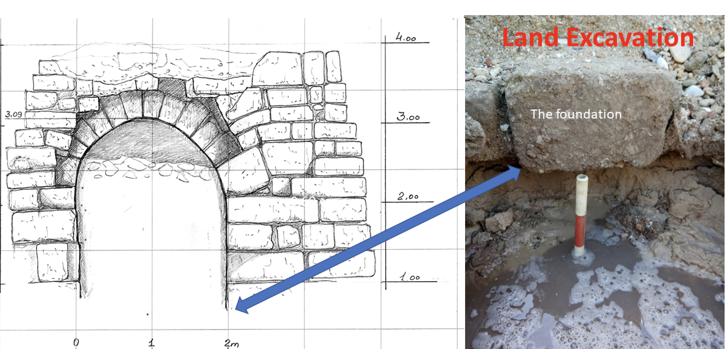
Onshore -the sewage channel was re-exposed, cleaned and partially excavated. The purpose of the excavation was to reach the bottom of the channel and determine the point at which the sewage channel is at sea level. The excavation was essential for checking the channel slope and coring onshore was taking. The highest marks of the sewage channel above sea level were measured by using RTK (Real Time Kinematic), and for the lowest marks of the sewage channel, a 150 cm long sediment core onshore was recovered. From Charcoals samples from the sewage channel remains were sampled and radiocarbon (C-14) dated based on radiocarbon.
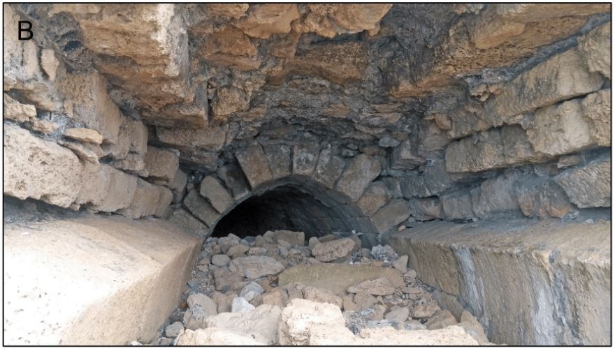
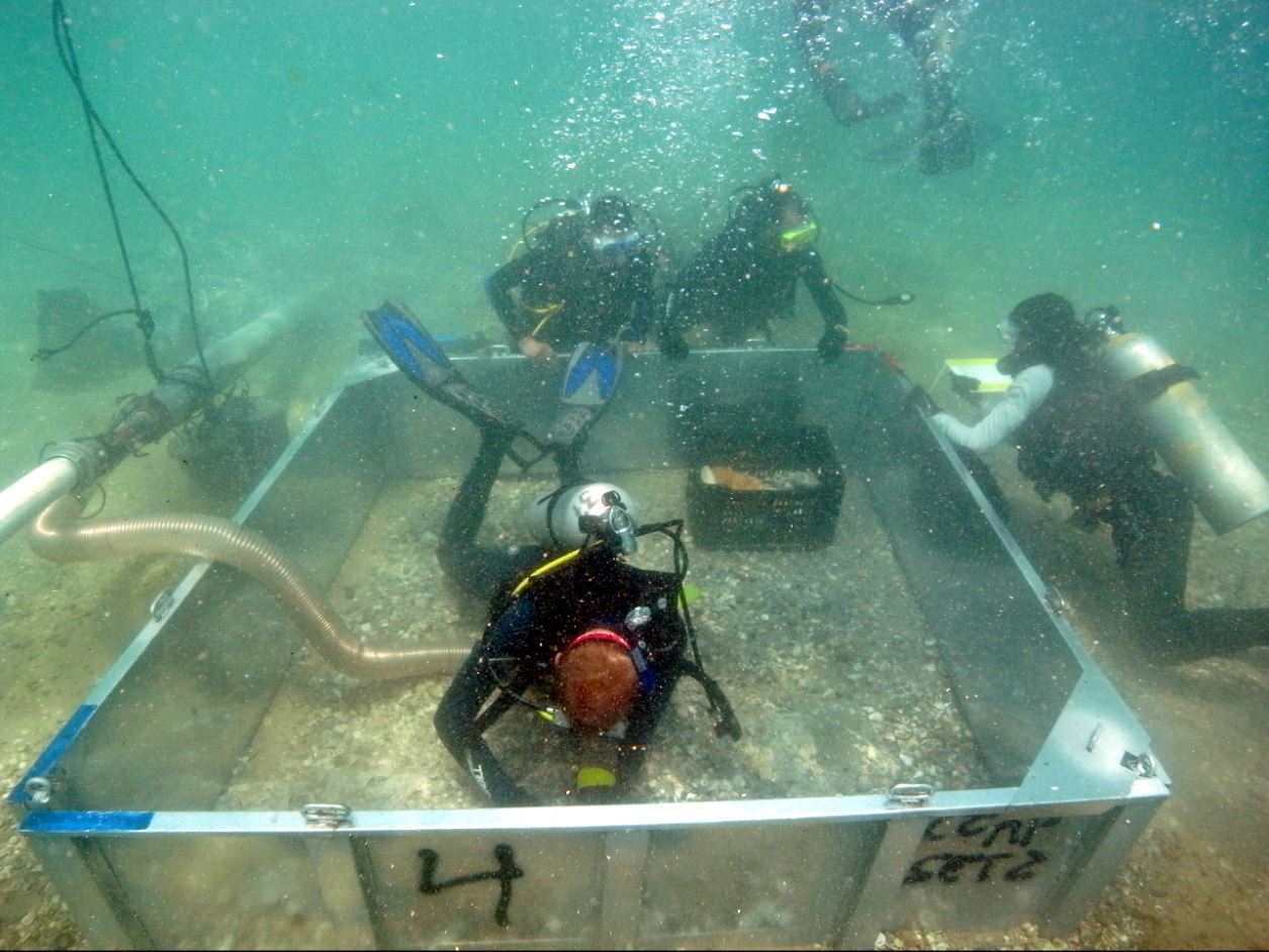
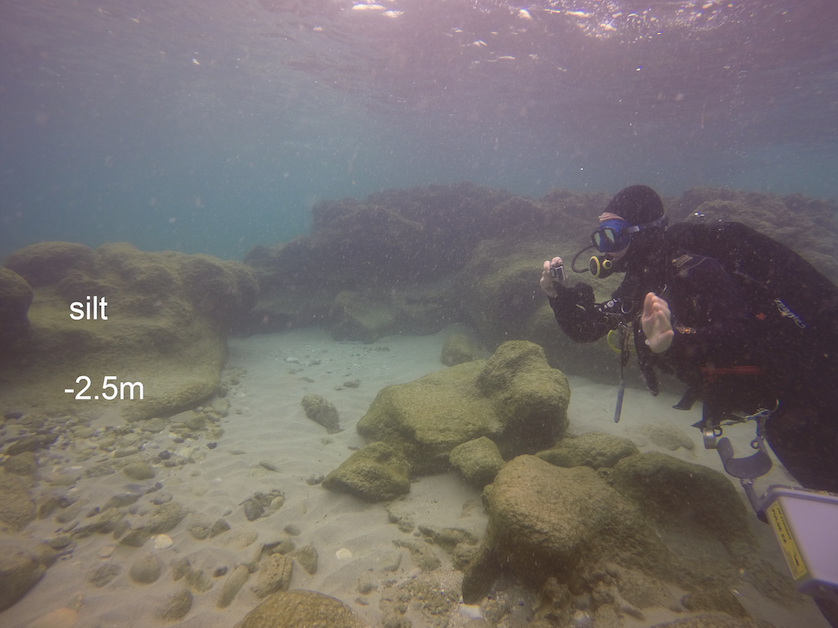
Offshore – While the remains of the western side of the sewage channel were only possible to approach and photograph from the sea by swimming the seafloor and the location of the sewage channel were directly measured and mapped by scuba divers up to 10 m water depth. the seabed up to 10- m- water depth deep, swimming west from the sewage channel remains on the beach. The divers mapped the seafloor and took pictures.
Result
Library/Archives
1. The sewer channel experienced went over two major destruction events. The first one occurred between 1921 and 1925 and the second in 2010. The northern anchorage of Caesarea coastline changed in the twentieth century.
Onshore
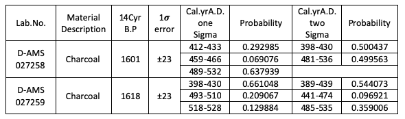
1. The age of the channel structure was determined using radiocarbon dating of charcoal extracted from the cement of the walls. Considering the 1 sigma age range of 412– 528 and 2 sigma age range of 398– 535 AD (Table 1).
Table 1 Radiocarbon dating (directAMS)
2. The sewage channel slope was estimated at 2.7%; calculating the slope with the length of the surviving channel shows that from the Byzantine period, the shoreline has moved eastward at least 30 meters.
Offshore
1. At a depth of -2.8 m, clay and an eolianite were exposed with various finds from the Roman and Byzantine periods. No foundations of construction or a layer of mud that could have been evidence of contents of sewage were visible.
Conclusion
The sewage channel slope was estimated at 2.7%; calculating the slope with the approximate length of the channel shows that from the Byzantine period, the shoreline has moved eastward at least 30 meters.
Caesarea’s Cloaca Maxima: Reconstructing Past Coastlines and the Secrets of Ancient Infrastructure project can determine the position of Byzantine coastline by measurable data. The results of the study indicate that from the Byzantine period, the shoreline has moved east at least 30 meters.