
Batroun, Lebanon – 2017-20
Clement Flaux and Nicolas Carayon
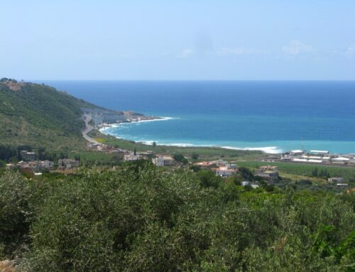
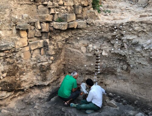
Image – A- View of the Phoenician (?) sea wall from inland. Graeco-Roman potsherds found within a beach-rock deposited above the quarry floor provide a terminus ante quem for the exploitation of the quarry. B- Partial view from the north-east of the Phoenician sea-wall maritime façade. The partial preservation of a notch and a clear step at its base, observed above the modern abrasion platform, provide possible evidence of the surrection of the area.Batroun is located 53 km north of Beirut. The coast is characterized by a rocky promontory made of calcareous sandstones (coastal aeolianite locally known as ramleh), separating two coves on its northern and southern sides. The ancient city was located above the rocky promontory, the western side of which was exploited as a quarry during Antiquity remains of which include the quarry floor and an impressive sea-wall, 220 metres long with a mean width of 1-2 metres and a maximum height of 5 metres.
Previously very limited archaeological investigation has been undertaken at Batroun, although the city is mentioned in the Amarna Letters from the second half of the second millennium BC. Later historical sources continue to mention, although infrequently, Batroun which appears as a modest coastal city throughout its long history, except during the reign of the Severans (early 3rd century AD). It has been suggested that the coves north and south of the promontory of Batroun, although able to host harbour installations, were too small to make Batroun an important maritime city. It is eventually believed to have been destroyed by a violent submarine earthquake and a subsequent tsunami during the 6th century AD.
Our project mainly aims at introducing a geoarchaeological perspective to the study of Batroun’s history. The site indeed presents coastal potential (harbours / quarries) and constraints (relative sea-level and coastal changes, high-energy events such as storm and tsunami). Three fieldwork missions undertaken along Batroun coast northward to Anfeh opened four areas of interest.
Geomorphology of the Phoenician sea-wall quarry in Batroun shows at least two steps in the quarrying process (fig. 1). A first excavation stage was done down to mean sea-level. Abandoned rock-cuts were sealed into a beach-rock. One bone included within the beach-rock matrix was radiocarbon dated from 14 +/- 60 cal. yr AD. In situ vermetid fixed upon the beach-rock was radiocarbon dated from 170 +/- 90 cal. yr AD. Association of beach-rock and in situ vermetid remains have recorded a fossil shoreline elevated at +0.9 m above the modern one, possibly uplifted during the AD 551 earthquake. Batroun coastal quarry surrection made possible a second excavation stage, also led down to mean sea-level. A second beach-rock formed from rock-cut debris above the quarry floor. Ceramics, coins, and one bone radiocarbon dated show that the beach rock formed during late antiquity.
The quarry floors are thus dated from Antiquity while the initial stage of the quarry exploitation remain still unknown. Incoming cosmonucleid datings are being tested to further decipher the Phoenician (?) sea-wall history.

Fig 1: Synthesis of Batroun sea-wall stratigraphy : two excavation stages and two quarry floors recovered by beach-rock remains from Roman times.

Fig. 2 : a fragment of column found next to the entrance of the modern harbour of Batroun.
Cores taken at Batroun’s modern harbour showed that the coastline in this area did not prograde during Holocene times. By contrast, core CAR01 made above al-Jawz river coastal floodplain, north of Batroun, shows that this area recorded more than 20 m of Holocene sediment, especially 15 m of organic muds radiocarbon dated from 7175 +/- 130 to 4670 +/- 110 cal. yr BC. Those archives provide potentially valuable palaeo-environmental proxies contemporaneous with installation and development of early Neolithic culture in the area of Al-Jawz watershed. In this regard, pollen analysis should be tested along the sequence.
Underwater survey of Batroun shores revealed only a few archaeological artefacts, including mansonry blocs (fig. 2) and one anchor.
Some 80 sites with coastal erratic boulders, 0.3 up to 6 m3, were recorded between Batroun and Anfeh coast during our surveys. The distribution of boulders usually facing SE-NW section of the coast as well as their imbrication (fig. 3, 4) suggest that high energy events which removed them from the coastline were originated from the south-west. Dominant southwestern winds and swells along the Lebanon coast suggest that boulders record palaeo-extreme storm events. However, most of boulders sites also face Ras Chekka northern cliff which is marked by giant rockslide escarpments (fig. 3). The rapid collapse of a great quantity of material into the sea could have triggered a local tsunami that could explain the cluster of coastal erratic boulders in this area. Such wave could also explain the distribution of underwater archaeological artefacts of various nature, size and age mostly found along a topographic escarpment south of Anfeh promontory.

Fig. 3 : Aerial photograph of the study area showing distribution of erratic boulders found
along the coast. The insert show a perspective view of Chekka promontory northern face, with
numerous rockslide scarps. Images : © Google Earth.

Fig. 4 : Example of imbricated boulders along a SW-NE direction at the southern shore of
Anfeh promontory
Geoarchaeological Survey of Batroun 2017 – Clement Flaux and Nicolas Carayon
Geoarchaeological Survey of Batroun 2018 – Clement Flaux and Nicolas Carayon
