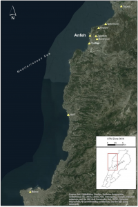
Anfeh, is a village in the Koura district of the North Governorate of Lebanon. It is located 15 km south of Tripoli and 70 km north of Beirut. The coastal village is extended by a noseshaped promontory, 400m long with a maximum width of 120m and oriented on an eastwest axis and separated from the hinterland by three moats to the east.
The latter promontory is called Ras al-Qalaat and is roughly oriented on a NNW-SSE axis while rising some 14 metres AMSL. Anfeh is delimited by the village of Chekka and the Barghoun River to the south, the agricultural area of Hraishi to the north followed by the village of Qalamoun, and the villages of Barghoun and Zakroun towards the east. The coastline north of Ras al-Qalaat is exposed as it offers no lee from the dominant SW winds. It consists of cliffs that drop in places onto a narrow rocky shore that is hazardous for seafaring.
Closer to the peninsula, the coastline forms two large well-protected shallow bays – the Nhayreh Bay and the bay of Ras al-Safi – that offer natural havens . Due to coastal urbanisation that started developing in the 1980s, both sides of the Nhayreh Bay are occupied by modern beach resorts. This leaves a narrow space in the bottom of the bay for the present-day modest fishermen’s harbour. To the south of Ras al-Qalaat, the rocky shoreline is low-lying and consists of a small cove with an open bay that are suitable for anchoring and landing places when the northerly winds blow, being in the lee of the promontory.
Anfeh’s coastline is also characterized by raised erosion platforms and wavenotches, as well as a series of submerged reefs running parallel to Ras el-Qalaat on a NNWSSW direction, and submerged terraces with marmites in shallow near-shore waters.
The site of Anfeh has been studied since 2010 by the Department of Archaeology and Museology (DAM), University of Balamand, under the direction of Dr. Nadine Haroun- Panayot and testifies to an occupation of the promontory of Ras al-Qalaat and the modern town of Anfeh that extends most likely from the Early Bronze Age to the Ottoman period.
From 2015-2018 Lucy Semaan undertook a Post-Doctoral Fellowship funded by the Foundation to consider the development, significance, and affordances of the seascape of the ancient site of Anfeh, and to look into how people used and modified this seascape through time.
features of a felucca
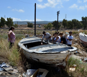
In 2014 Julian Jansen van Renburg undertook an ethnographic project to record the tangible and intangible maritime heritage of the Anfeh seafaring community, this included a two day maritime ethnography workshop to train Lebanese participants in the principals, techniques and ethical considerations of maritime ethnographic recording, a link to the report can be found below.
Throughout the centuries Anfeh’s fishing community have been using their knowledge and skills to make their living from the capricious seas surrounding Ras Anfeh, a promontory located 15 km south of Tripoli and 70 km north of Beirut. The fishermen’s traditions are representative of the culmination of several hundred centuries of engagement with a range of different cultural groups, each of which has left their own cultural imprint. Unfortunately, with the modernisation of the fishing fleet over the past decades many of these traditions in Anfeh, as elsewhere in Lebanon, are being consigned to an unrecorded part of ‘Levantine history’ (Starr 1977: 57-70; Pinello, & Dimech 2013). This project was undertaken in response to this direct threat to the maritime traditions of the fishermen in Lebanon, by focusing initially on the small fishing community in Anfeh.