Seafaring in the Shadows: Revealing Maritime Traditions of Chalcolithic Cyprus- Ongoing
Dr Victor Klinkenberg- Postdoctoral researcher, Archaeological Research Unit, University of Cyprus
In this project we aim to rectify the persistent misconception of the Chalcolithic as a non-maritime culture. This misreading is rooted in the scarce evidence for the exploitation of marine resources, and long-distance trade, which were abundant during the preceding Aceramic Neolithic, and the later Bronze Age. Most archaeologists therefore describe Chalcolithic communities as ‘standing with their backs to the sea’ (cf. Knapp 2020). However, recent skeletal evidence indicates that a substantial portion of the population of the Chalcolithic was involved in (still undefined) aquatic activities. Also, field surveys indicate that the larger, more complex settlements were located near the coast, suggesting that the sea was important. A likely explanation can be found in another hallmark of Chalcolithic culture, namely, the significance of regional exchange networks. We propose that these networks relied heavily on seafaring and that we must appreciate Chalcolithic life as dependent on seafaring activities.
Given that pack animals were not present, transport either took the form of human portage or seaborne transport. In this project we want to explore both these possibilities. The focus is on Western Cyprus, which has been well investigated and which is poorly connected via land routes to the rest of Cyprus. A reconstruction of the ancient coastline and identification of possible landing spots for prehistoric vessels will support the analysis of settlement location preference. Subsequently we will apply least cost path analysis to determine the likely land and sea routes between known settlements, as well as the energy requirements for both modes of transport. These analyses will help elucidate the relationship of Chalcolithic communities to the sea and contest the persistent misconception of this period as strictly non-maritime.
Reconstructing the exchange network of West Cyprus.
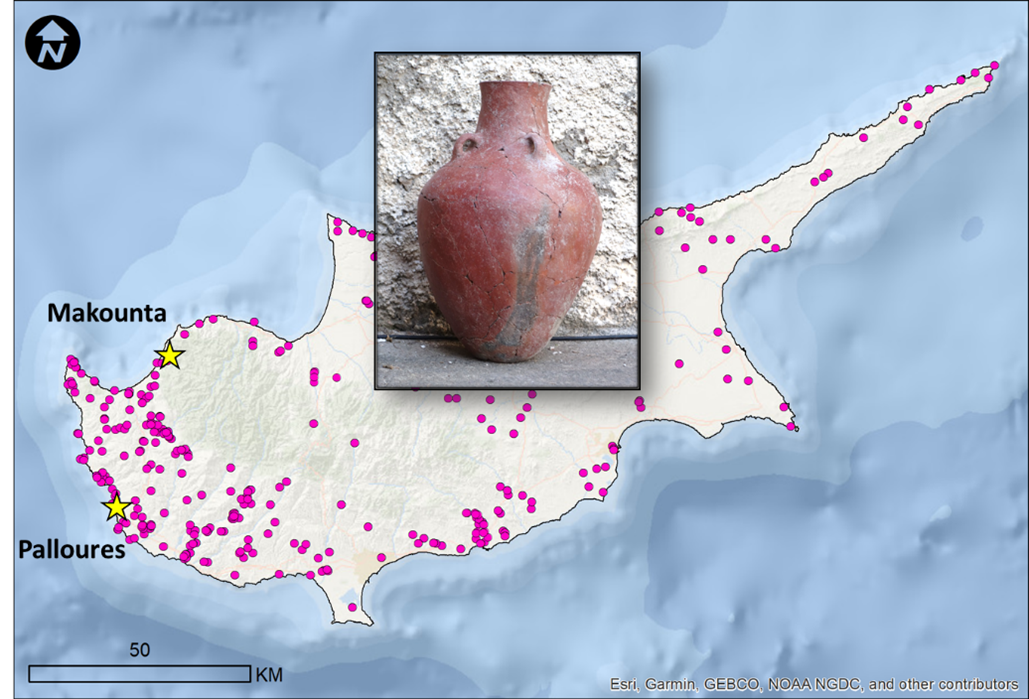
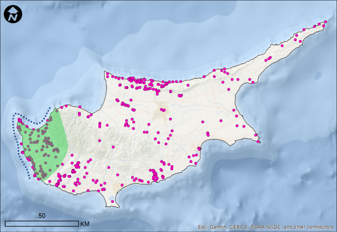
In western Cyprus a vast number of settlements are known, with all large settlements located near the coast. The exchange network between these settlements was extensive. From petrographic analysis of pottery from the coastal site of Palloures, near Paphos, it is apparent that at least 10% of the pottery, including large storage jars, most likely originate from the area of Chysochou Bay, some 45 kilometres as the crow flies (figure 1). The energy required for the transport of such jars, and probably the goods they contained, could have been significantly reduced by sea travel. Given the prevalence of non-local artefacts in assemblages observed at archaeological sites, it is thus likely that the sea offered an important transport corridor for the mutual exchange of goods, people and ideas. Currently, it is not well-known where the ancient coastline of the period was located, and which landing spots for boats were available, especially along the generally rocky coast along the Akamas Peninsula. Also unknown is in how far the use of sea routes would have reduced the amount of energy required for transport. These data are essential to establish the nature and relative importance of seafaring.
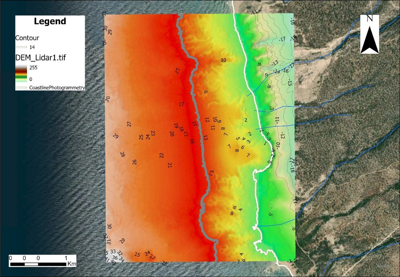
Coastline reconstruction.
To understand the connectivity between Chalcolithic settlements and the sea, it is imperative to know the location and physical nature of the contemporary coastline. Due to sea-level rise of some four meters, the coastline has moved up to 200 meters inland in the last 5000 years, effectively drowning the Chalcolithic coastal landscape. Settlements that are currently coastal, may have been located much further inland when they were occupied, whilst coastal Chalcolithic sites may now be submerged beneath the sea. Further, coastline morphology, sea currents, and topography have changed over time, which means that areas which currently offer easy marine access, were possibly less accessible in the past. Vice versa, ancient beaches, coves and bays may have been drowned and are now inaccessible. Understanding the Chalcolithic coastal zone thus requires detailed geomorphological reconstruction.
To reconstruct an area of such large extent, in this project we will reconstruct the coastal landscape of the Chalcolithic period using desk-based methods, specifically remote sensing techniques. The technique has the great benefit that a large area can be covered in a short time frame. It further offers a basis for later, higher-resolution investigations. Remote sensing refers to the use of satellite imagery, aerial photography, LiDAR (Light Detection and Ranging), and other sensors to collect data about the Earth’s surface without physical contact. Our available data includes High-resolution satellite images, aerial photographs, captured from planes or drones from multiple time periods, and we have access to highly detailed LiDAR datasets of the coastal zones of Cyprus. LiDAR technology uses laser beams to create highly accurate 3D maps of the Earth’s surface, and can reveal hidden archaeological features beneath dense vegetation, modern structures or underwater. We will combine remote sensing data with brief archaeological ground-truthing to verify the desk-based modelling. All remote sensing data will be integrated into GIS software, which allows for the creation of landscape maps and visualizations.
After detailed analysis and reconstruction has been undertaken, the paleo-coastline will be analysed using GIS for the potential for small vessels to access the water and to land. Based on variables of the beach morphology, sea action and land-based accessibility, the coastline will be indexed for likely landing spots, or zones of marine access for prehistoric vessels. These results will be compared to the observed settlement distribution of the area, to help understand the likely relationship between these settlements and maritime practices. As such, this project will reveal the currently drowned coastal landscape of the Chalcolithic.
Routes on land, connections by sea.
Reconstructing the possible transport routes between sites of the region is based on the assumption that people chose routes that were the most efficient in terms of energy requirement, so-called least cost paths (LCP). No pack animals were available in the Chalcolithic, so the land-based routes entail pathways for people, with or without handcarts. Reconstructions are based on elevation models, geology models and natural barriers such as steep ravines and will be undertaken using GIS.
Using the reconstructed coastline and possible landing spots as a base and using data on seasonal sea currents and wind direction, the likely maritime routes will be reconstructed for the changing weather conditions throughout the year. Routes are calculated for sailing and non-sailing vessels.
The two modes (sea vs land) of transport are compared to each other by calculating how much energy was required for the transport of goods along the reconstructed network. The results of these calculations will reveal in what manner the Chalcolithic settlements of western Cyprus were interconnected, and specifically what the role of seafaring was.
The project is novel because it systematically quantifies different scenarios for archaeologically observed connectivity in the Chalcolithic. The project is valuable because it will reveal a hitherto invisible, drowned coastal landscape of prehistoric Cyprus as well as the exchange network that depended on maritime movement. The project will help to remedy the persistent notion that Chalcolithic people “stood with their backs to the sea”. The methodological basis of the project is coastal modelling and GIS analysis, which are the areas of expertise of the team members and all necessary digital datasets are directly available.
The project and team members will be embedded in the Digital Humanities Geoinformatics Laboratory of the Archaeological Research Unit of the University of Cyprus. Following the core philosophy of the laboratory, this project seeks to harmoniously integrate methodologies from hard sciences with archaeological inquiry, aiming to provide novel, creative solutions for persistent questions in the field. The project represents a significant step in our careers, serving as the basis for further developing our research portfolio and in the aspiration to secure permanent positions in academia.