Partners:
CMAUCH, University of Alexandria, Egypt
Department of Underwater Antiquities, Ministry of Antiquities, Egypt
MarEA, Universities of Southampton and Ulster, UK
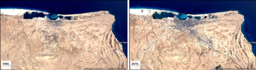
The Mediterranean coastline of NW Egypt is under threat, predominantly from agricultural and urban expansion (Figure 1). Today much of the coastline is being rapidly developed for commercial and hotel real estate purposes, resulting in the loss of invaluable heritage. If sites are not properly surveyed, documented and reported to the authorities soon, they could be lost forever.
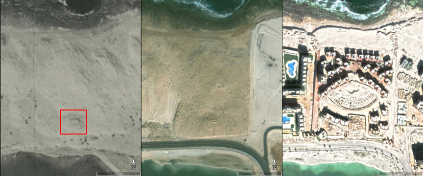
To address this, the NW Egyptian Marmarica Coast Survey is undertaking targeted survey of the little-studied, 200-mile coastal strip from Marsa Matruh west to the Libyan border at El Salum. Key areas and heritage sites have been identified through a remote-sensing survey of the region using historic satellite imagery and aerial photographs, as well as previous survey reports, coupled with an assessment of threats and damage to archaeological sites.
Phase 1 of the project involved a remote-sensing survey of the region using historic satellite imagery, aerial photographs and previous survey reports to identify heritage sites. In conjunction with desk-based assessment of threats and damage to the sites caused by natural causes as well as urban, touristic and agricultural expansion, heritage sites and key areas to target have been identified.
In Phase 2 physical surveys, both in the coastal zone and underwater, will be conducted to verify and record sites identified through the desk-based survey, as well as determine the nature and scale of threat. All sites will be mapped to the highest possible standard using GIS and photogrammetry. Furthermore, remote sensing and GIS applications will be employed to detect changes of the coastline over time. A final threat and impact assessment report will be produced, along with a mitigation plan to help protect the heritage in this region.
References
White, D. (1989). Excavations on Bates’s Island, Marsa Matruh: second preliminary report. Journal of the American Research Center in Egypt 26: 87–114.
White, D. (2002). Marsa Matruh I: The Excavation. The University of Pennsylvania Museum of Archaeology and Anthropology’s excavations on Bates’s Island, Marsa Matruh, Egypt, 1985-1989. INSTAP Academic Press (Prehistory Monographs, 1).