Beirut Port Project 2021 - 2023
Naseem Raad
Beirut is one of Lebanon’s most extensively excavated, surveyed, and published coastal archaeological sites. However, these excavations and surveys were undertaken by a number of teams and researchers, each conducting independent fieldwork using different methodologies and approaches. As a result, there did not exist any holistic central database of all completed work in the city. For this reason, the Beirut Port Project (BPP) was envisioned by the Honor Frost Foundation to collate all extant archaeological data from previous work in the city in one central database. This database is meant to serve as a working template for all organisations involved in salvage operations and cultural heritage management projects.
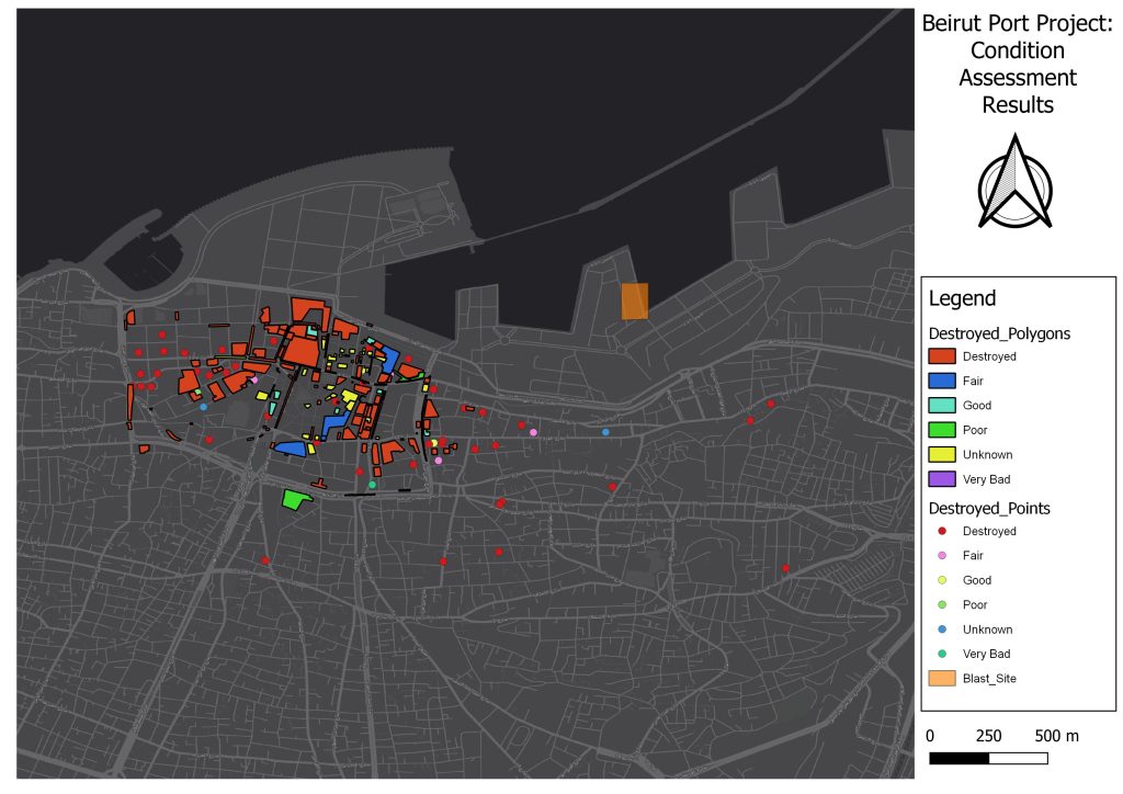
The BPP database was modelled after those of EAMENA and MarEA to work towards a unified and relatable GIS across multiple projects. By conforming to the structure of EAMENA and MarEA databases, results of the BPP can be easily transferred and are immediately relatable. After all archaeological data was gathered and processed, the team also conducted condition assessments of these sites led by Dr Sayantani Neogi. The purpose of these condition assessments were to trace patterns of disturbances in the city, and also identify current threats to the preservation of archaeological sites and features.
This endeavour represents one part of a larger, multi-disciplinary effort by a number of organizations in collaboration with the DGA to record, conserve, and maintain the maritime cultural heritage of Beirut. The BPP database can now be used as the basis for the completion of full and comprehensive impact assessments to heritage sites in case of urban developments or other projects that might lead to their degradation. It also allows for efficient data sharing with relevant institutions and partners. Further sites in Lebanon will be assessed in a similar manner based on the methodology of the BPP, and it is the hope that these works catalyse digitisation efforts for Lebanese archaeology as a whole in one centralised format.
For inquiries contact the project director, Dr Naseem Raad at naseemraad@honorfrostfoundation.