Kieran Westley (School of Geography & Environmental Sciences, Ulster University)
Introduction
Aerial and satellite remote sensing play a key role in archaeological research and heritage management by enabling rapid cost-effective site prospection, landscape characterization, and facilitating change detection and risk assessment. However, traditional approaches based on optical/multispectral satellite images are less effective in watery environments. In theory, their effectiveness could be enhanced by applying additional processing to standard multispectral satellite images to:
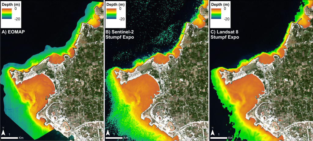
1) Obtain quantified seabed depths for shallow water (Satellite Derived Bathymetry [SDB])
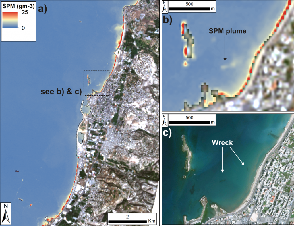
2) Map Suspended Particulate Matter (SPM) concentrations which can reveal wrecks via disturbances they create in sediment transport patterns.
Therefore, the aim of this project was to assess the effectiveness of the aforementioned techniques for maritime cultural heritage research and management. This assessment was conducted in the eastern Mediterranean, specifically Egypt (Nile Delta), Lebanon (Tyre and Sidon) and Syria (Ras Ibn Hani).
Method
The SDB assessment tested medium-resolution (10-30m) bathymetric models derived from freely-available satellite images (Landsat 8, Sentinel 2) using empirical ratio-transform methods from the scientific literature, as well as high-resolution (2m) models purchased from a commercial provider (produced using a physics-based approach). Assessment of archaeological effectiveness was based on the models’ ability to inform submerged palaeo-landscape reconstruction and detect submerged anomalies (i.e. shipwrecks). This component of the project was applied to sites in Lebanon (Tyre) and Syria (Ras Ibn Hani)
The SPM assessment was based on application of a published algorithm for SPM mapping to Landsat 8 image collections through a bespoke Google Earth Engine Script. Assessment of archaeological effectiveness was based on whether the patterns of SPM flow showed any relation to submerged obstructions and/or known shipwrecks. This component of the project was applied to sites in Egypt (Nile Delta) and Lebanon (Sidon).
Results
Results of both assessments were somewhat mixed. All SDB approaches were capable of producing reasonably accurate generalized bathymetry, but absolute depths varied depending on the ratio-transform method/algorithm employed (Fig. 1). The ability to detect submerged archaeological features such as harbour structures and wrecks was also found to be poor. That said, the SDB was capable of highlighting larger elements of the submerged palaeo-landscape (e.g. offshore ridges, palaeo-channels) and providing an input surface to palaeo-geographic reconstruction which is intermediate between globally-accessible but low resolution data, and expensive and spatially restricted but high-resolution swath bathymetry.
The SPM approach did work in places, and clear modifications of surface sediment patterns by submerged obstructions were noted (Fig. 2). However, these were rare, and effectiveness in the study sites (and perhaps the Eastern Mediterranean in general) was reduced by prevalent local conditions which include a lack of regular tidal currents, highly variable (often low) sediment supply, and the morphology of the submerged obstructions themselves.
Although both SPM and SDB approaches were found to be less effective for archaeological prospection than initially hoped, they are useful getting a broader sense of the landscape and environmental context in which archaeological sites are located. This information can then be used for palaeo-geographic reconstruction, site formation process studies, hydrodynamic modelling, assessment of archaeological potential and planning field survey. Coupled with their relative ease of operation and the frequent lack of data that characterizes many offshore environments, they do offer a means of gaining at least some insights that would not otherwise be possible. As such, they have a place in the maritime archaeological toolbox, but will be variably rather than universally effective depending on local conditions in which they are applied and the archaeological questions or management issues being addressed.