Surveying coastal submerged archaeological sites using UAVs and drones - 2016
Dimitrios Skarlatos
This project aimed to develop new means for archaeological coastal mapping and detection, using technologies that are recently becoming affordable, such as Autonomous Unmanned Aerial Vehicles (AUAV or drones). Image Based Methods (IBM) such as Structure from Motion (SfM) and Multi View Stereo (MVS) for 3D recording and documentation are becoming more popular thanks to improved image processing algorithms, while impressive level of detail and precision is attained. Therefore the use of fixed wing UAVs and multicopters for 3D mapping and orthophotos production is widely recognized and becomes accepted as a standard tool for archaeological site documentation or excavation progress monitoring, although there are still limitations and constrains.
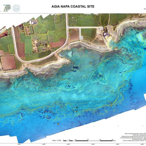
Since aerial imagery may penetrate more than 13m in clear Mediterranean waters, coastal archaeological areas could also be benefited by mapping and monitoring using similar techniques. Processing though is not trivial, as the straight rays of light are refracted on sea surface. This affects both the 3D bathymetric model as well as final orthophotomosaic accuracy. The latter is also affected by lack of control points from the sea side, as practice and theory suggest that control points (points of known coordinates) must be measured along the perimeter of the area of interest. This project will propose methods and algorithms to address these problems and streamline the process of creating bathymetric contours, orthophotomosaics on coastal shallow waters for survey, detection, documentation and monitoring of coastal archaeological sites.
Brief Final Report
A new iterative methodology and corresponding algorithm have been developed to correct the problems of water refraction in aerial photos over coastal sites, hence allowing for the first time seamless correct orthophotomaps to be created over archaeological coastal sites. Through the use of reference data (provided by EAC in Dekelia and DLS in Amathounta), the project proved that using commercial automated techniques for image rectification in coastal areas, produces nice but erroneous results.
The proposed methodology and algorithm are iterative. This is unavoidable, as the water depth is also an unknown along with the amount of refraction. Since the refraction effect is more prominent in lower flying heights, the proposed methodology is more important if more details of the sea bottom are needed, such as in archaeological surveys. The most important aspect of this work is that is allows a unified, seamless and accurate DEM and orthophoto over coastal areas. As a by-product, one may use the method to accurately calculate depth of up to 13m approximately, depending on weather conditions and water clarity. Prior to this work, submerged areas were difficult to process photogrammetrically and only a few points could be processed, enough only for a vector diagram. The new method (fig. 1) proposes correction of the raw data, the photos themselves, hence all further processing can be accommodated by standard photogrammetric and computer vision software. Once the ‘new’ photos were created, a ‘new’ provisional DSM is produced. This new DSM is a better approximation of the depth, and is being used again in order to producing a new set of provisional photos, corrected from refraction. This process is being repeated until the DSM shows no significant change, usually 3-4 times, as evaluated with against bathymetric checkpoints. The final photos are used to rerun the aerial triangulation allowing for a new camera self-calibration, in order to produce the final DSM and orthophotomap, previously impossible to attain.
A statistical analysis of the comparison between the extracted corrected depths and the reference depths was performed. The mean, standard deviation, error percentage and Root Mean Squared Error (RMS) show the improvement in the depth values extracted from the DEMs after each iteration. The error percentage of the provisional DSM decreased from 39.5% to 15.6% after the first iteration, down to 9.1% after the second iteration, and finally to -1.40% after the third and last iteration. This is also indicated by the decrease in the mean, from 1.07m to 0.08m as well as the decrease in RMS from 1.41m to 0.53m. The standard deviation however, is slightly increased after the first iteration, compared to the provisional DSM, even though all other statistical error indicators are greatly decreased. This is because the spread of the depth values, even though corrected remains the same.
There are of course shortcomings as well. The sea surface is assumed to be flat, because the ripples are insignificant to flying height. The depth extraction is limited by water clarity and underwater visibility, which might not always be the case in sandy seabed and turbulence. The process is iterative, hence more time consuming than traditional DSM and orthophoto creation. Nevertheless, this work proves that refraction significantly affects depth estimation, and if not taken into consideration severe depth miscalculation will occur. At the same time this work provides a valid and accurate alternative for depth extraction and orthophoto creation in coastal sites, a possibility which previously was not an option at all.
For more info, see in publications area:
2016, Skarlatos, D., Savvidou, E. Coastal Survey of archaeological sites using drones. Skyllis journal, accepted, in press.
2016, D. Skarlatos, E. Savvidou. Coastal Survey of archaeological sites using drones. Deguwa XXI, ‘In Poseidon’s reich’, Dresden, 21-24 April, 2016 [presentation]