Project Summary
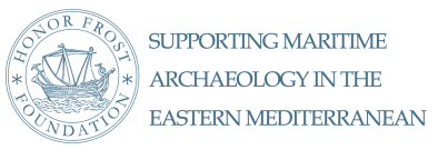
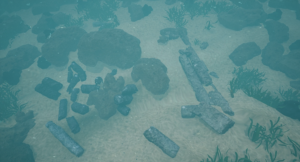
The shipwreck site of Capo Taormina off the coast of Sicily consists of a cargo of 37 fragments of columns and two blocks of marble previously investigated in 1959 by G. Kapitan who produced a plan and carried out initial analysis on the marble (Kapitan, 1961). It lies on a rocky slope from 22 to 29 m deep on the extremity of Capo Taormina. The site was investigated as part of the ‘Marble Routes Project’ (http://virgo.unive.it/archeomar/rottemarmo.html) which aims to reconstruct the dynamics of the marble trade and the characteristics of the ships used to carry these special cargos in the Roman period.
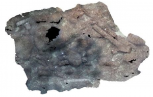
A 3D model of the site has been created using photogrammetry which has allowed the team to better measure each block. This new investigation has also shown that seven fragments of columns were illegally removed from the site after Kapitan’s survey. The measurements and the 3D model have also allowed the team to reconstruct the minimum tonnage of the cargo (81 tons), whilst analysis of the only three items recovered from the site and now in the museum of Naxos has allowed them to propose the minimum length of the ship (20m) as well as providing a tentative date for the sinking between the 2nd and 3rd century. Sampling of each block has also verified that they were made from the same marble type, analysis on six of them has led to the identification of the provenance of the stones to the island of Teos in Turkey. They are of Africano, that is Marble Luculleum, a green rubble stone.
Survey Methodology
This mission has resulted in a new 3D photogrammetrical documentation of the site, integrated with a DSM measurement of a net of control points, which has also allowed the team to compare the situation seen in 1959 with the actual current situation.
The particular morphology and depth of the site allowed the team to advance in the testing of automatic photogrammetry. In order to maintain the same pixel resolution of the images and a unique scale of the virtual model it was necessary to remain the same distance from the subject, parallel to the sea bottom. However in order for the divers to maintain a good dive profile they had to move across the site taking photographs in lines at decreasing depths without going down again. Photos were taken over two different dives due to the dimension of the site and to the limited dive time; the divers took around 600 images for every photogrammetric block, which have been arranged in the same reference system thanks to the topographic survey with DSM measurement.
Except one diver, who was also the site physician, and the director of the mission (Carlo Beltrame), the divers were students of the BA (3) and MA (2) in Archaeology. The team was completed by the Research Fellow Stefania Manfio, an expert in virtual reality, and Elisa Costa, a PhD candidate working on 3D documentation in naval archaeology. Students had the opportunity to train in underwater documentation, processing of digital data, and sampling of marble as part of their education programme in Maritime Archaeology.
The team has also documented a column recovered from the site between the 1970’s and the 80’s and displayed in the AtaHotel, which cannot be identified in the 1959 plan.
Each marble element has been precisely measured to obtain a tonnage in order to reconstruct the cargo as well as the ship shape, they have also been sampled for analysis.
The three items recovered in the 1959 survey (a sounding lead, a lead ring and a bronze bolt) have also been studied to try to establish a date for the shipwreck and the potential size of the ship.
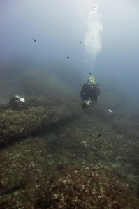
Initial observations of the blocks show that they appear to come from the same type of marble, therefore the team decided to analyse just six of them. The analysis was carried out at the LAMA laboratory of the IUAV University of Venice, leader in this field. The analysis, made by Lorenzo Lazzarini, has been of two types:
1. X ray diffraction (XRD) on powders of the tout venant of the samples for the determination of the crystalline phases which are present. Diffractionmeter PANanalytical, EMPYREAN, radiation CuK./Ni at 40 Kv and 40 mA.
2. Optical microscope on thin sections, on polarize light transmitted, for the identification of the main and ancillary mineralogical components. The microscopic and the composition characteristics of the samples suggests these are the so called Marmor Luculleum or Africano, a calcareous rubble quarried close to the city of Teos, now occupied by the village of Sigacik, Smirne (Turkey) and imported to Rome by the first half of the 1st century BC.
Results
As a result of the new survey the team have concluded that seven of the 38 fragments of columns seen in the 1959 survey are no longer present. Two square blocks are still in situ at the extremities of the bigger columns that form the cluster of marble which maintains the position it had in the original cargo. The other fragments of columns are scattered along the rocky slope.
The new documentation and analysis of the marbles of the shipwreck of Capo Taormina have allowed the team to reconstruct a cargo of 31 fragments of columns and two blocks in situ to which they have added the column of the AtaHotel and the seven fragments of columns documented by Kapitan but not present on the seafloor anymore. The central cluster is composed of two blocks and three columns, still in the cargo position, 6.12 m long and with a maximum volume of 3.72 m3. The total volume of the conserved and unconserved marbles is 30.04 m3, that is 81 tons. The marble has been identified as Africano that is Marmor Luculleum, a green calcareous rubble coming from the island or Teos, in Turkey. The dating of the cargo, based on the items recovered, is between the 2nd to the 3rd century AD. The same objects allowed the team to propose that the ship could be more than 20 m long.
3D Modelling and Virtual Reality (VR)
The images acquired during the photogrammetric survey were processed using Photoscan software to obtain a detailed and accurate 3D model. Subsequently, every single mesh of the columns and blocks was imported into Rhinoceros software to create the final 3D model removing the irregularity of the concretions and the seaweed on the marble. The portion of the columns and blocks under the sand was not visible in the photogrammetric model obtained, therefore the original form in Rhino was reconstructed.
In addition, the team created a Virtual Reality tour of the site. Unreal Engine 4 software, developed by Epic Games, was used to recreate the Capo Taormina’s underwater archaeological site. First, they uploaded the 3D elaboration of the site and the sea-bottom. Second, the underwater environment elements were elaborated and texturized using 3D CAD software and then uploaded in Unreal Engine 4. This included animated elements, such as fish and eels, and static objects, such as flora (local seagrass and seaweed plants). Finally, in order to obtain a realistic virtual underwater scenario, some graphic effects were applied, such as refraction, fog, caustics, and dirty mask. Regarding settings, the light was designed to reproduce the actual depth of the underwater sites. The navigation starts from the water surface, thus the user is able to simulate a real dive, further enriching the virtual experience. In addition, the interface was designed to allow the user to freely navigate or “swim” through the site using the keyboard or a gamepad.
Future Plans
The team are now finalising the hypothetical reconstruction of the cargo and the proposal of the ship size. Once this is completed the results will be published and the shipwreck will then be compared with other cargos of marble investigated during the project to reconstruct the dynamics of the marble trade from the eastern to the western Mediterranean and to define the characteristics and tonnages of the ships used to transport these special cargos.
References
Kapitan, G., 1961, Schiffsfrachten antiker Baugesteine und Architekturteile vor den Kuesten Ostsiziliens, Klio, 39, pp. 276-318.